
For a fiber network owner, getting a route from a line on a map to conduit in the ground takes more than engineering and a construction crew.
In some Colorado municipalities, sits one of the most important parts of an underground OSP build: plan and profile development, municipal review, and permitting.
Across the Denver metro area, municipalities increasingly want detailed information about how a proposed fiber route will interact with existing infrastructure before they authorize construction. That can mean identifying utilities through Subsurface Utility Engineering (SUE), potholing existing facilities, documenting horizontal and vertical clearances, developing plan and profile drawings, and responding to municipal engineering comments.
For a network owner, this is not simply a permitting exercise. Plan and profile review can determine whether the route that was designed can actually be built—and how quickly construction can begin.
At Trace Fiber Services, permitting is integrated into the OSP construction process. Our team self-performs permitting and works directly with municipalities throughout the Denver metro area, while coordinating the field work required to move a route from preliminary design through approved construction.
What Is a Plan & Profile for a Fiber Build?
A fiber plan and profile shows a proposed underground route from two perspectives.
The plan view shows the route from above: the proposed conduit alignment, right-of-way, streets, structures, existing utilities, bore pits, handholes and other relevant features.
The profile view shows the vertical relationship below ground. It documents the proposed bore depth and the vertical separation between the new fiber conduit and utilities such as water, sanitary sewer, storm sewer, gas, electric and existing communications infrastructure.
That second view is especially important in crowded urban rights-of-way and will get updated as potholing occurs.
A route can look perfectly reasonable on an aerial map while presenting an entirely different problem underground. A water main, storm structure or existing duct bank may occupy the same vertical space the proposed bore was intended to use.
Plan and profile work turns those unknowns into construction information before the drill head goes underground.
Where Plan & Profile Fits in the OSP Construction Cycle
A typical underground fiber build moves through several interconnected stages:
Route design → utility investigation → potholing/SUE → plan & profile → municipal review → construction permitting → OSP construction → fiber installation and splicing → testing and closeout
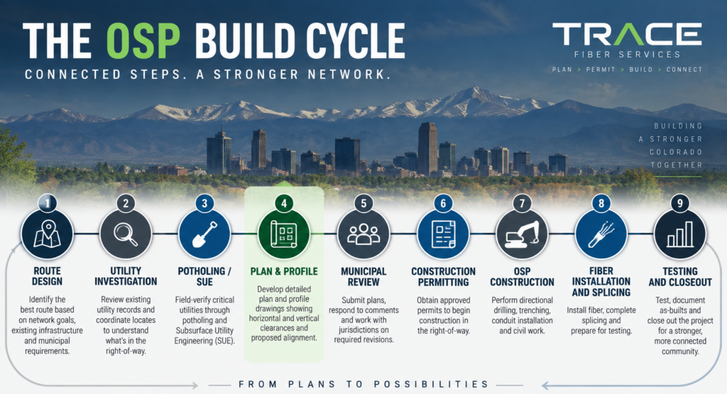
One important note is that these stages can often not be managed independently because there are dependencies between them.
A preliminary route may identify where the network owner wants the fiber to go, but the plan and profile process determines how that route interacts with conditions in the field.
If a proposed bore crosses a municipal water line, for example, the jurisdiction may require that utility to be physically exposed so its depth can be verified. Those pothole results can then be incorporated into the profile, allowing the municipality to confirm that the proposed bore maintains the required clearance.
If the clearance does not work, the route or bore depth may need to change.
That is why plan and profile review belongs inside the OSP build cycle—not outside it as an administrative step.
Potholing Is Often the Link Between Design and Plan & Profile
Before a municipality can approve a proposed underground alignment, it may need better information about existing utilities. This is where potholing and Subsurface Utility Engineering become important.
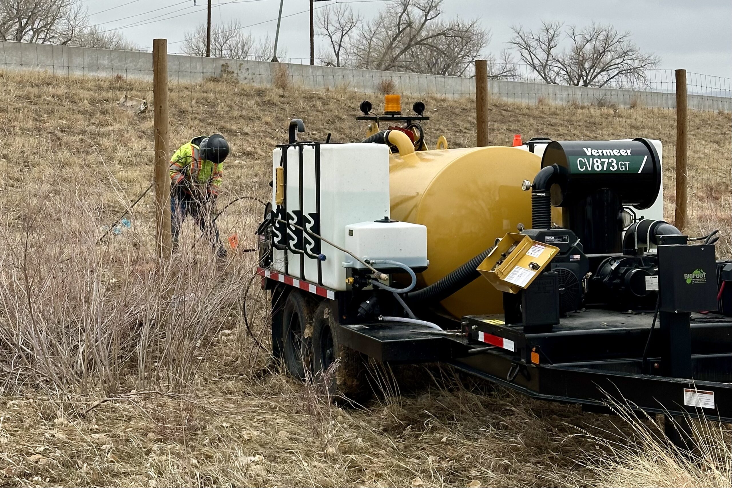
Existing records and utility locates can establish an approximate horizontal location but are generally not sufficient to establish vertical depth. At critical crossings, however, the actual depth may need to be field verified. A crew exposes the utility at a specific location, records the information, and feeds that data back into the engineering and permitting process.
The result is a much more useful profile.
Instead of showing that a proposed fiber bore simply “crosses a water line,” the plans can show the measured elevation of the water line, proposed bore elevation and required separation between the two facilities.
For the network owner, this work reduces uncertainty before full production begins but introduced an intermediate step. Measuring the existing utilities requires deploying a pothole crew (also known as daylighters or vac crew) to collect field information.
Municipal Review Is Part of Constructability
Municipal plan review serves an important purpose prior to permitting. Public rights-of-way throughout the Front Range are increasingly crowded, so the Colorado jurisitictions responsible must work to decrease risk to existing facilities.
A single corridor can contain:
- Water mains
- Sanitary sewer
- Storm drainage
- Gas lines
- Electric cables
- Traffic signal infrastructure
- Legacy telecom (POTS)
- Multiple generations of fiber.
Cities need to know where another facility is going before allowing it into that environment.
For contractors and network owners, the key is understanding those requirements early enough to incorporate them into the build schedule.
A plan reviewer may request additional potholes, revised clearances, different bore depths or modifications to a proposed alignment. If the permitting team understands both the jurisdiction’s requirements and the construction method, those comments can be addressed with the end build in mind.
That becomes particularly valuable on large fiber deployments that cross several jurisdictions. A network route through the Denver metro area can move from one municipality to another in a relatively short distance, while the permitting and engineering requirements can change at the city limit. A current Trace project has three different municipalities intersecting at a single intersection.
Colorado Jurisdictions Where Plan & Profile Requirements Commonly Come Into Play
There is no single Denver-metro plan and profile standard. Network owners should evaluate the requirements of every jurisdiction their route enters. As a start, the Colorado Department of Local Affairs (DOLA) provides geospatial data sets that can be used to perform initial analysis.
Colorado jurisdictions that require plan & profile (or fiber review) include:
CDOT Right-of-Way
Not every OSP route is controlled by a municipality.
When construction enters or crosses Colorado Department of Transportation right-of-way, another permitting process comes into play. CDOT’s utility permit application requirements include a plan and profile showing the relationship of the proposed facility to the ROW and existing utilities, along with other required documentation such as traffic control.
That becomes especially relevant for long-haul and metro fiber routes that cross state highways. CDOT also has the added requirement of 3rd party inspectors during construction, in an attempt to gather more exact data about the facilities in their rights of way.
Requirements change, and individual projects may trigger additional engineering, SUE, traffic control or permitting standards. Network owners should confirm current requirements for the specific jurisdiction and route before construction.
What Efficient Plan & Profile Management Looks Like
Efficient plan and profile work is not about pushing drawings through review as quickly as possible.
It is about giving the municipality the information it needs while keeping the plans aligned with what crews can actually construct.
For Trace, that means coordinating permitting with route review, utility information, potholing, construction planning and municipal comments.
When a reviewer asks for additional field verification, the request does not have to disappear into a chain of vendors. When field conditions require an adjustment, the permitting team understands why the change is being made. And when the permit is released, the construction team has context for the decisions reflected in the approved plans.
That continuity matters on any OSP project, but it becomes increasingly valuable as the number of route miles, utility crossings and municipalities increases.
From Permit Set to Fiber in the Ground
Plan and profile is sometimes viewed as a hurdle between engineering and construction.
A better way to look at it is as the point where the two meet.
It is where a proposed route is tested against the actual underground environment, where municipal requirements become construction requirements, and where potential conflicts can be resolved before they become field problems.
Trace Fiber Services provides a single-source approach to OSP network deployment across Colorado, including engineering coordination, permitting, potholing, directional drilling, civil construction, traffic control, fiber installation, splicing and testing.
For network owners building in the Denver metro area and across the Front Range, that means the people navigating plan and profile review understand what comes next: we have to build it.
Planning an OSP fiber build in Colorado? Contact Trace Fiber Services to discuss permitting, plan and profile coordination, construction and fiber deployment.